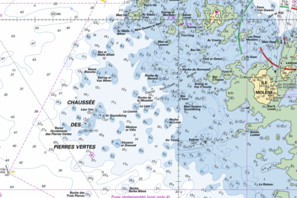
Never go sea fishing without preparing your trips. 30 minutes on a map can save hours of prospecting. Success depends on accurately locating the fish. Use high-quality charts to identify variations in relief and ocean currents, crucial clues for finding the right spots. And for this, there's a free website called Data.SHOM, backed up by the SHOM 1D book, which explains everything you need to know. I'll tell you everything you need to know here.
Drop-offs and breaks, use bathymetry
Bathymetric curves indicate the slope of the bottom. Narrow isobaths indicate abrupt changes in depth, or favored fishing spots such as drop-offs, shoals or breaks. These spots are easy to spot. The succession of numbers indicates the depth, and the space between the curves measures the gradient.
Examine the chart closely. Note sudden changes, drops, breaks, oyster beds and currents. Good fishing spots accumulate many favorable clues, so pay attention to these details. It's all on the chart.
The colors and numbers on the map indicate the seabed. White areas for greater depths, blue for less than 10 m, green for foreshore, and bistre for land. Understand the numbers and lines on the probes for accurate reading.
Validate this underwater relief with your fishfinder for more accurate fishing. Your own echo sounders, or pay-per-use charts such as Navionics, will give you more detail and bathymetric curves.
Understand the nature of the seabed with your map
Decipher the chart by knowing the nature of the bottom. Use codes to identify the type of bottom, whether sandy, rocky, muddy or other. Adapt your fishing techniques accordingly.
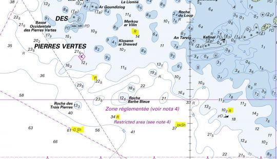
You can see in yellow above that letters appear on your cartography. These letters refer to the nature of the seabed, and their meaning can be found in the SHOM 1D book (page 35.) from which the following extract is taken.
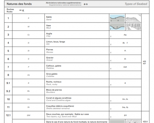
This makes it easy to choose rock for pollock or sand for turbot.
Other interesting spots include artificial structures
Every structure in the sea (natural or man-made) becomes a concentration point for fish, as a potential shelter or feeding area. Submerged rocks, wrecks and buoys are all good fishing spots, indicated by pictograms that can also be found in the SHOM book.
First of all, the rocks, which are important to know, if only for their navigational hazards. Easy to recognize on the map, here are the pictograms.

Then there are the shipwrecks, where we can unearth some lovely places and bars.
Now you're ready to study the charts to find the best positions for the fish you're looking for.
To help you find your way, here are the most suitable areas for some species:
Ôeurosó┬ Bars: rock head or wreck with rock bottom and current zone
Ôeurosó┬ Location: wreck, rock head on rocky bottom and deep area
Ôeurosó┬ Turbot: ridin┬ and sandy zone
Ôeurosó┬ Raie: zone of fairly fine gravel
Whether your passion is surfcasting, lure fishing or boat fishing, marine cartography is your ally. Be methodical in your chart analysis, and careful and attentive on the water. I hope you'll be able to get even more out of your boat fishing trips by preparing this one even better.

 /
/ 